The full moon kept it from ever getting dark, so it was hard to tell when the sun started coming up. I checked my phone. It was a few past 7, and my portable battery had successfully given it a full charge. We stayed warm through the night under our quilt, but my sleeping pad had slowly lost air. I feared it got a hole, but upon quick inspection I noticed the release valve wasn’t completely tight. We changed back into our dirty clothes, ate breakfast, and packed up our gear. A few minutes ahead of schedule, we continued down the dirt road for almost a mile until we came to the foot trail.


We had arrived at the Rogers Trough Trailhead and the end of passage 18. We stopped to brush our teeth and sign the register before heading on.

Our descent took us into Rogers Canyon, where seasonal springs are present. In addition to the 18 miles to conquer before our intended camp site, we also had the task of finding water. Heather and I had about 2 liters apiece.


Less than a mile in we said good morning to a group of 3 packing up camp. We passed a few puddles of standing water, but opted not to stop. Checking my AZT app on my phone, I was able to see notes from previous hikers that there were more reliable sources ahead. The trail broke away from the wash, and we started a steady climb through thick manzanitas and other hardy shrubs up towards Reavis Pass.


Barely breaking a sweat, we reached the top of the pass, and then the scenery changed dramatically to high grasses, alligator junipers, and a variety of pines.


We were greeted to a beautiful valley by this stump, and we added our obligatory rock.


Reavis Creek joined the trail, and we soon found an area with light flow. The clear water was perfect, so we stopped to refill 6 liters. That was my first time drinking filtered water, and it was crisp, cold, and delicious! It was such a nice area we stayed for lunch and took another liter after we finished. Two different groups with dogs passed by while we were stopped. The trail had gotten busier, and we were close to Reavis Ranch.

The Superstitions have a lot to explore, and one of them is a place called Circlestone. A colleague recommended we visit the archaeological ruins, but it meant taking a 2.4 mile side trail up one of the peaks southeast of Reavis Ranch. That would raise our mileage for the day to 22+, but we decided it was worth the extra challenge. From our lunch spot, we crossed the creek several times over the next half mile before reaching the junction to the Fire Line trail. We hid our packs under a tree and grabbed a liter each, then headed up the rocky trail.


It sure was nice not to have to carry our packs for a change! We kept going for about a mile and half where we found the unmarked Circlestone trail.


The trail got a little steeper as we climbed sun-ward. In a clearing we caught our first glimpse of Four Peaks, and I started thinking about the brewery with its namesake. With my mind distracted, we shortly came to the stacked rock ruins. You can see the circle in this Google Maps aerial view. We took a few minutes to walk the perimeter, and said hi to a group of 4 who were chatting in the center.


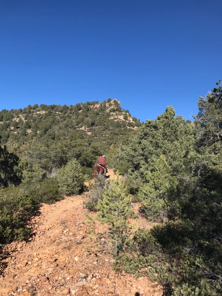
It was cool but not impressive, and we didn’t have much time to spare. After a few minutes at the top, we headed back down. We stopped for a couple of equestrians to pass. Riding their horses from Reavis to Campaign, the lady rider greeted me with a “Nice hat!” She too was wearing the AZT Ranger, and they too were racing the sun. After pleasantries we both moved on in opposite directions.

Nearly 2 and a half hours later we were back on the AZ trail. We were strolling right along when suddenly the pretty got prettier. Walking over an old concrete foundation, we had arrived at Reavis Ranch, a deserted homestead and apple orchard.


There were dozens of trees still holding fruit. We tried one. Delicious! Sweet, crisp, and not tart. Pulling apples from the branches, there were so many on the ground I slipped a couple of times as if I were standing on marbles. We chatted with another couple and gathered a couple handfuls of apples to take with. Reluctantly we moved on, racing the sun.


As we exited the ranch, we must have passed at least 10 tents set up for camp. We pressed on, climbing Reavis Gap. Once we hit the other side, we were in the shadows. Determined to get to camp, we hiked as fast as we could. The sun was going down quick, and Four Peaks had become a silhouette.


Not discouraged by the lack of sunlight, we strapped on our headlamps and continued down the mountain. The slopes were steep and slick, bringing us to our butts several times. We had our poles packed so we could move fast, but we were forced to take them out to help us keep our balance. Click-clacking in the darkness, we spotted another head lamp ahead. We had arrived at Walnut Springs and met Glenn who was seeking trees big enough for his hammock. After getting some advice, we came to realize we weren’t making it to our planned site. It was a steep 2-mile climb to get there. Instead, we found the only level spot along the trail and shared it with our new friend. There were no trees so he cowboy camped next to our tent under the bright moon.

As we wound down for the night eating jerky, cheese, and other snacks, we learned Glenn was also from Tucson backpacking the exact same sections. That was his Malibu back at the start. He had started a day before us, and we had caught up to him.

Day 2: 14 miles (plus 4.8 off-trail)


One thought on “Reavis”